
The Andes - Altitudinal zonation
Economy and land use
978-3-14-100890-6 | Page 195 | Ill. 2
Overview
A comparison: The difference in mean annual temperatures between Juba (Sudan) and Magdeburg is 18.7 degrees Celsius, and the distance between the two places is 5600 kilometres. The same temperature difference can also occur, for example, between Mont Blanc (4810 m high) and the Tête de la Charme lift station (1870 m), which is only six kilometres away as the crow flies, i.e. between valley locations or alpine pastures in the Alps and their highest peaks.
Therefore, the high mountains of the Earth are marked by characteristic natural altitudinal levels, in which a characteristic vegetation formation has developed on the basis of the concrete climatic conditions. This has been altered in many places by human intervention. Therefore, certain forms of use often also characterise the respective altitude level.
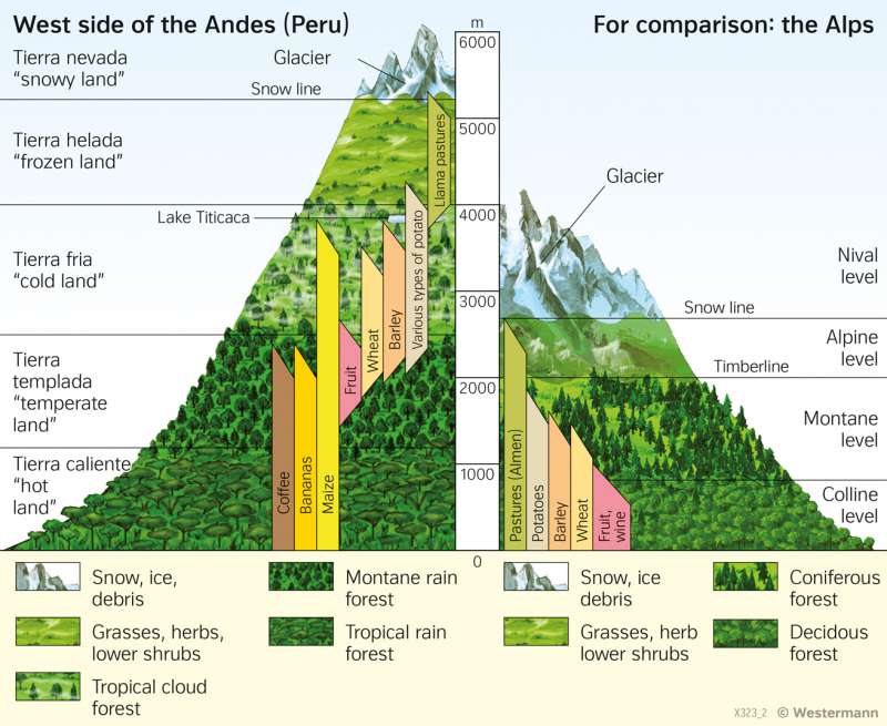
Comparison of two altitudinal zonations
The diagram shows a comparison of the altitudinal zones of the Alps and the Peruvian Andes. Above the snow line, there is the tierra nevada or nival stage, characterised by sharp-edged rocky peaks and glaciation. Since the Peruvian Andes are closer to the equator, the snowline there is around 2500 metres higher than in the Alps. The tierra helada of the Andes below the snow line resembles the alpine level of the Alps with its grass, herb and shrub formations.
There is no equivalent to the scattered cloud forest formations of the Andes (tierra fria) in the Alps. The climate there is humid and uniformly cool all year round. Within Europe, it is most comparable to the mild oceanic climate of southern Ireland. Below the tierra fria, there are dense, closed forests whose character changes with increasing temperatures (for example, with regard to species composition and growth heights). Between sea level and about 1200 metres altitude, tropical rainforest is naturally widespread. In the Alps, the areas below the timberline are occupied by coniferous, mixed, and deciduous forests; for the purpose of agriculture, they have been widely cleared there and converted into grassland.
